The fenland clays and river terrace gravels of Peterborough present a unique resistivity challenge. Seasonal saturation shifts the water table by over a metre between the Nene's winter peak and late-summer lows, directly altering bulk ground conductivity. A standard desk study misses this. We run vertical electrical sounding arrays specifically timed to capture worst-case saturation, because the difference between a dry gravel lens and a water-filled one changes your foundation impedance numbers substantially. For sites near the Flag Fen basin, where Holocene peat lies interbedded with clay, we often combine VES with a CPT campaign to calibrate the resistivity profile against measured pore pressure dissipation curves.
A 15% error in electrode spacing produces a 30% error in apparent resistivity—we stake out to 2 cm because the fenland clays don't forgive sloppy field practice.
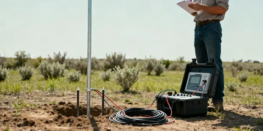
Our approach and scope
Site-specific factors
Peterborough's expansion onto former brick pits and backfilled clay workings has left a legacy of unmapped fill. The city grew fast post-1960s designation, and not every old extraction site made it onto the BGS drift maps. We've encountered 4-metre-thick bands of saturated ash and clinker where the borehole log said 'firm clay'. That's a differential settlement risk no amount of conservative bearing pressure can fix. VES picks up the low-resistivity signature of water-saturated fill and the high-resistivity signature of buried brick rubble in a way that a standard window sampler probe simply cannot. On one Fengate site, a 2D resistivity line flagged a buried channel at 6 m depth that three trial pits missed entirely—the channel was only 2 m wide. Without that line, the piled foundation design would have been dangerously under-length on the western third of the slab.
Regulatory framework
BS 5930:2015 + A1:2020 — Code of practice for ground investigations, BS EN 1997-2:2007 (Eurocode 7) — Ground investigation and testing, BS 1377-3:2018 — Methods of test for soils for civil engineering purposes (chemical and electro-chemical testing, relevant for resistivity correlation), ASTM D6431-18 — Standard Guide for Using the Direct Current Resistivity Method for Subsurface Site Characterization (referenced for international projects where client requires ASTM alignment)
Linked services
1D Vertical Electrical Sounding (VES)
Single-location depth investigation using Schlumberger array. Ideal for foundation bearing stratum verification and groundwater table profiling. Output is a resistivity-depth curve with interpreted lithology.
2D Electrical Resistivity Tomography (ERT)
Multi-electrode profile lines for cross-sectional imaging. Deployed for cut-and-fill boundary mapping, buried activities detection, and karst feature identification in the Lincolnshire Limestone formation.
3D Resistivity Grid Surveys
Grid-based acquisition for volumetric ground models. Used on complex brownfield sites where fill distribution varies in all three dimensions and targeted excavation planning is required.
Typical parameters
Q&A
What depth can a VES survey reach on a typical Peterborough site?
With a maximum AB/2 current electrode spacing of 150 m, we reliably resolve resistivity to approximately 40–50 m depth. The actual depth of investigation depends on the subsurface resistivity contrast—a conductive clay cover will attenuate signal more than dry gravel. For deeper targets we can extend the array, though site access constraints in urban Peterborough often dictate the practical limit.
How much does an electrical resistivity survey cost in Peterborough?
A single VES sounding typically ranges from £530 to £910 depending on maximum depth required and site access conditions. A 2D ERT profile line of 100–200 m length falls within a similar bracket per line. We offer fixed-price quotes after reviewing your site location and investigation objectives.
Can resistivity distinguish between Oxford Clay and overlying gravel in the Nene Valley?
Yes, and with strong contrast. Dry to damp Quaternary gravels in the Peterborough area typically read 80–200 ohm-m, while the Oxford Clay formation sits at 5–15 ohm-m when saturated. The interface is sharp on inverted sections. We calibrate the boundary depth against at least one borehole or dynamic probe log on each site to tie resistivity to lithology definitively.
How long does a resistivity survey take on site?
A single VES sounding takes roughly 45–60 minutes including setup and breakdown. A 200 m 2D ERT line with 4 m electrode spacing typically requires 2–3 hours of field time. Data processing and inversion add a further day in the office. We schedule surveys around weather windows—heavy rain saturates the near-surface and temporarily reduces contact resistance, which helps data quality if managed correctly.