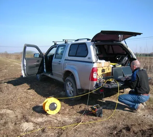
Peterborough's expansion from a medieval market town on the Nene's gravel terraces to a modern logistics hub has pushed development onto increasingly challenging ground. The city sits at the edge of the Fens, where Oxford Clay and Cornbrash limestone dip beneath thick sequences of peat and soft alluvium. Victorian engineers learned the hard way that what looks solid from the surface can hide metre after metre of compressible silts. Today, before anyone drives a pile or cuts a basement, the subsurface needs to be imaged clearly. Seismic tomography gives us that image. By measuring how compressional and shear waves travel through the ground, we can build a velocity cross-section that distinguishes competent limestone from weathered clay or loose fill, without the gaps inherent in a borehole log. When we run a seismic refraction line across a proposed warehouse footprint near Fengate, the resulting tomogram often reveals buried channels or solution features that a grid of boreholes might miss entirely.
A seismic velocity inversion across Peterborough's river terraces can distinguish compact gravel from peat in a single afternoon of fieldwork.
Our approach and scope
Site-specific factors
The Cornbrash limestone beneath Peterborough has a well-documented history of dissolution, particularly where groundwater flow concentrates along joint sets near the Nene valley margins. Cavities a metre or more across have been encountered during piling for commercial developments off the A1139. A borehole can hit solid rock and miss a void 2 metres away; seismic tomography, by measuring the continuous velocity field between source and receiver, reveals these features as pronounced low-velocity shadows that interrupt the otherwise competent limestone signature. Equally dangerous are the peat lenses within the Holocene sequence: they generate very low shear-wave velocities and can produce differential settlement severe enough to crack slab-on-grade floors within the first year of service. Shallow gas from organic decomposition adds another layer of complexity, attenuating seismic energy and requiring careful source-receiver geometry to maintain signal quality. Our inversion routines flag these anomalies explicitly in the deliverable, so the structural engineer can decide whether to bridge them with deep foundations or redesign the ground improvement scheme.
Regulatory framework
BS 5930:2015+A1:2020 – Code of practice for ground investigations, BS EN 1997-2:2007 (Eurocode 7 – Part 2: Ground investigation and testing), BS EN ISO 22476-1:2023 – Geotechnical investigation and testing – Field testing
Linked services
Seismic Refraction Tomography
P-wave first-arrival tomography for mapping rockhead depth, identifying weathered zones, and estimating rippability across proposed foundation footprints in the Peterborough area.
Seismic Reflection Profiling
High-resolution SH-wave reflection surveys to image stratigraphic boundaries, buried channels, and fault offsets within the Oxford Clay and Cornbrash sequences below the Nene floodplain.
Crosshole Seismic Tomography
Velocity imaging between pairs of boreholes or CPT soundings to characterise the stiffness of individual soil layers for settlement analysis and dynamic modulus derivation.
Integrated Geophysical-Geotechnical Interpretation
Combined analysis of seismic velocity sections with borehole logs, CPT profiles, and laboratory dynamic test results to produce a unified ground model for foundation design.
Typical parameters
Q&A
How much does a seismic tomography survey cost for a typical industrial plot in Peterborough?
For a standard commercial or industrial lot in Peterborough, seismic tomography surveys generally range from £2,190 to £3,670 depending on the total line length, the number of geophone channels deployed, and whether a single refraction line or a crossing grid is required. Access constraints, traffic management on active sites, and the need for SH-wave reflection to resolve deeper stratigraphy can shift the cost toward the upper end of that bracket. We offer a fixed-price proposal once we review the site layout and the target investigation depth.
Can seismic tomography detect dissolution cavities in the Cornbrash limestone under Peterborough?
Yes, this is one of the primary reasons clients commission tomography in the city. A cavity or highly weathered zone within the limestone produces a sharp drop in P-wave velocity that appears as a distinct low-velocity anomaly on the inverted cross-section. The resolution depends on geophone spacing and the cavity's size relative to the wavelength, but features as small as 1 to 1.5 metres across can often be identified with a 1-metre sensor interval. Confirming the anomaly with targeted drilling or a CPT test is standard practice.
How long does fieldwork take for a seismic refraction line in an urban Peterborough site?
A single 48-channel refraction line with a length of 47 to 94 metres typically requires a half-day of fieldwork, including equipment setup, multiple shot points, and demobilisation. If we are laying out a grid of several intersecting lines or working around active construction traffic, the survey may extend to a full day. Processing and interpretation usually add another 2 to 3 working days before the draft report is issued.
What depth of investigation can seismic tomography achieve in the Peterborough area?
With a 48-channel array and a 2-metre geophone spacing, P-wave refraction tomography routinely images to depths of 15 to 25 metres below ground surface, which is sufficient to reach the top of competent Cornbrash limestone across most of the city. SH-wave reflection surveys, when ground conditions are favourable and surface waves are managed, can extend the depth of investigation to approximately 35 metres, capturing the contact between the Cornbrash and the underlying Blisworth Limestone or Northampton Sand Formation where it is present.